Please use this identifier to cite or link to this item:
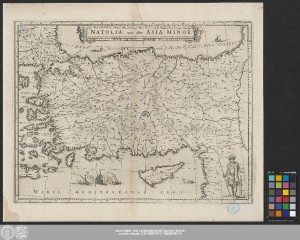
http://dx.doi.org/10.25673/39336| Title: | Natolia, quæ olim Asia Minor |
| Publisher / Printer: | Blaeu, Willem Janszoon Blaeu, Joan |
| Published: | [Amsterdam] : [Blaeu], [1635] |
| Scale: | Circa 1:3 500 000 |
| Coordinates: | E 25°00'00"-E 42°00'00"/N 45°00'00"-N 34°00'00" |
| Extent: | 1 Karte; 37 x 49 cm Kupferstich |
| Annotations: | Bergzeichnung Titelkartusche oben Mitte. - Maßstabskartusche unten rechts Altkarte Auch erschienen in: Theatrum orbis terrarum, sive Atlas Novus. - Amsterdam : Blaeu, 1635 Erscheinungsjahr nach Erstausgabe des "Atlas Novus" |
| Language: | Latin |
| Online Edition: | Halle (Saale) : Universitäts- und Landesbibliothek Sachsen-Anhalt, 2021 |
| Original Publication: | Universitäts- und Landesbibliothek Sachsen-Anhalt, Altkt B II 7 [18] 4 |
| URN: | urn:nbn:de:gbv:3:3-1192015415-1725256487-15 |
| URI: | https://opendata.uni-halle.de//handle/1981185920/41292 http://dx.doi.org/10.25673/39336 |
| Open Access: |  Open access publication Open access publication |
| License: |  Creative Commons Attribution 4.0") (CC BY 4.0) Creative Commons Attribution 4.0 (CC BY 4.0) Creative Commons Attribution 4.0 |
| Sponsor/Funder: | Die Digitalisierung wurde durch die Deutsche Digitale Bibliothek im Rahmen des von der Beauftragten der Bundesregierung für Kultur und Medien (BKM) geförderten Programms NEUSTART KULTUR ermöglicht. |
| Appears in Collections: | Karten und Atlanten |
Ressources:
 |
|